View Larger Map
On Monday April 30
Between the two I-93 underpasses Hanson Brook has a nice small cascade
The trail itself is not very interesting, but it does pass by a few large boulders that I assume are glacial erratics, here is one of them
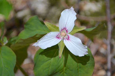
There were lots of flowers out, this is the first time this year I have seen wild flowers. Lots of painted trillium
including a nice pair
and a closeup
I also saw three flowers in various stages of opening up, from just starting to open
to more open
to almost fully open with the "leaves" (bracts to be accurate) still dark and curled
There were lots of purple trilliums, but most were hanging their heads down and not very photogenic, here is one that was looking up
and a closeup
There were lots and lots of hobblebush, but I only saw two flowers, one barely starting to open its buds
and the other a bit further along
I was at least half way up the mountain before I came across the first trout lilies, but once started they were abundant. Here are a bunch of them
and here is one that was smiling at the camera
From the south facing ledge just before the summit I took this photo to the southeast (click for larger view)
Little Coolidge Mountain is in the foreground. Behind it is the ridge from Loon Mountain (with remains of snow on the ski slopes), over Scar Ridge (with its slides) to Mount Osceola and its East Peak. Finally in the background we have Mount Tecumseh with the ridge over Green Mountain and Mount Dickey (many thanks to Steve Smith for help with the identifications!).
The east facing ledge is getting very grown in, but still has excellent views on Mounts Liberty and Flume through a gap in the trees
The view of Mount Lafayette is much more limited
A whimsical trail maintainer has marked the summit in an unusual way
I went down by the Mt. Pemi Trail towards the Flume, and soon saw an interesting band around a tree
No flowers on the north facing slope of the mountain! No views until the parking area, where there is a view from Mount Lincoln to Whaleback Mountain
The Corridor 11 snowmobile trail leaves the parking area at the western end (closest to Rt 3) of the most southern parking area, and a spur leads from it to the Indian Head Resort. In the photo below the arrow points to the continuation of the main trail, while the spur continues south to the resort
From Rt 3 there is a final view of Franconia Ridge


That curved arrow on the summit is probably for anyone up there in the fog; be sure to turn left now — don’t continue straight ahead.
ReplyDeleteLovely photos! I adore the mountain wildflowers.
ReplyDeleteAfter hiking in Switzerland, I applaud your enthusiasm for "hiking" in New Hampshire!
ReplyDeleteThanks for your page (not blog--I got here from there!) about staying at Lonesome Lake Hut. It was just the info. I needed. We're bringing our two and four year olds there tomorrow. Hike around the lake looks perfect. Thanks!
ReplyDelete