Friday, May 4, 2012

Mt Pemi Loop, April 30, 2012

Mount Pemi is close to my home, and is therefore my usual destination when I want a short non demanding hike.  In winter the trailhead on Rt. 3 is not plowed, so I do an up and down from the Flume side.  In all other seasons I usually do a loop, going up from Rt. 3, descending to the Flume, and returning to my car by a combination of snowmobile trail and road.


View Larger Map

On Monday April 30th I drove to the trailhead and about a mile before reaching it decided to stop and take a photo of my destination. Not easy with all the phone and power lines, but I eventually got a clear view!


 Shortly after leaving the trailhead I crossed a small field, and saw a flowering shadbush


Between the two I-93 underpasses Hanson Brook has a nice small cascade


The trail itself is not very interesting, but it does pass by a few large boulders that I assume are glacial erratics, here is one of them


There were lots of flowers out, this is the first time this year I have seen wild flowers.  Lots of painted trillium

including a nice pair


and a closeup


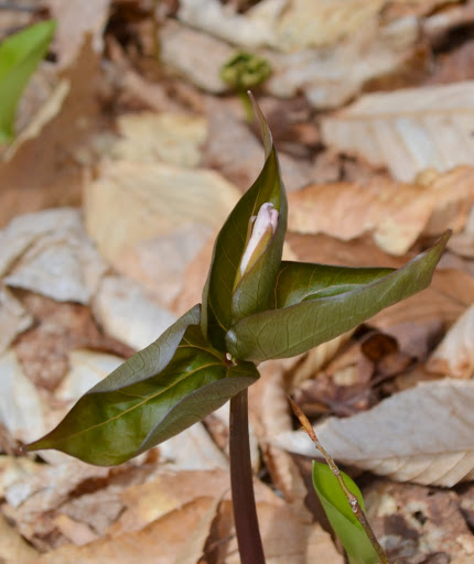
I also saw three flowers in various stages of opening up, from just starting to open


to more open


to almost fully open with the "leaves" (bracts to be accurate) still dark and curled


There were lots of purple trilliums,  but most were hanging their heads down and not very photogenic, here is one that was looking up


and a closeup


There were lots and lots of hobblebush, but I only saw two flowers, one barely starting to open its buds


and the other a bit further along


I was at least half way up the mountain before I came across the first trout lilies, but once started they were abundant.  Here are a bunch of them


and here is one that was smiling at the camera


From the south facing ledge just before the summit I took this photo to the southeast (click for larger view)


Little Coolidge Mountain is in the foreground.  Behind it is the ridge from Loon Mountain (with remains of snow on the ski slopes), over Scar Ridge (with its slides) to Mount Osceola and its East Peak. Finally in the background we have Mount Tecumseh with the ridge over Green Mountain and Mount Dickey (many thanks to Steve Smith for help with the identifications!).

The east facing ledge is getting very grown in, but still has excellent views on Mounts Liberty and Flume through a gap in the trees


The view of Mount Lafayette is much more limited


A whimsical trail maintainer has marked the summit in an unusual way


I went down by the Mt. Pemi Trail towards the Flume, and soon saw an interesting band around a tree


No flowers on the north facing slope of the mountain!  No views until the parking area, where there is a view from Mount Lincoln to Whaleback Mountain


The Corridor 11 snowmobile trail leaves the parking area at the western end (closest to Rt 3) of the most southern parking area, and a spur leads from it to the Indian Head Resort.  In the photo below the arrow points to the continuation of the main trail, while the spur continues south to the resort


From Rt 3 there is a final view of Franconia Ridge


Sunday, April 29, 2012

Up Book Signing, Lincoln, NH, April 28, 2012

This post is really only of interest to those who know, or know of, Trish, Alex and Sage, so I will not give any background.  Trish's book has just been published, and yesterday she was in Lincoln, NH, at the Father Roger Bilodeau Community Center.  She gave an excellent talk before she, and the girls, started signing books, chatting with everyone.  A very enjoyable evening, here are a few pictures (several more on my Picasa Web Album).

I arrived a few minutes before seven, the start time.  Entering the center I first saw Steve Smith, with a big box of books!


The girls were playing in a remote corner, here is Sage:


Here is Trish with the girls just before the talk


Steve introducing Trish


Trish talking


and reading from the book


Trish, Alex and Sage at the book signing table


and a closeup of Sage signing


Tuesday, April 17, 2012

Ellsworth Hill Road, 4/13/2012

A few days ago I posted a note on VFTT on Uphill walking in Campton to Lincoln area and two posters suggested that I explore Ellsworth Hill Road, at least to the site of the old inn, with the option of continuing up Mason Road and, if I felt energetic enough, Cook Hill Road.  Years ago I had driven up Ellsworth Hill Road a few times going to Three Ponds and to Carr Mountain, and I remembered that it was very steep.  A look at the map confirmed it; it would certainly be a good workout on a non hiking day!  I decided to try it on Friday 4/13.


View Larger Map

There is a big open space, suitable for parking, immediately east of the bridge across the Pemi on NH 49:

The bridge is narrow, so there is a pedestrian walkway on one side of it


The walk to the site of the inn is as steep as I recalled it, with very few semi open views, but on this early spring day the outlines of the mountains were visible through the leafless trees.  Opposite the inn is a very large clearing, with extensive views of the mountains, extending from Mount Lafayette, over Franconia Ridge, to Loon Mountain, Scar Ridge, Tecumseh (with the western peaks of Mount Osceola barely visible behind it), the Tripyramids with West Sleeper and finally Sandwich Dome.  Here is a wide view from Lafayette to Tecumseh (click on any of the photos for a larger version)


one from Tecumseh to Sandwich Dome


and one of the Tripyramids and Sandwich Dome


There are many more photos taken from the inn site on my web album Ellsworth Hill 4-13-2012.

I then turned onto Mason Road, and soon saw the first wild flowers I have seen this spring in New Hampshire


Shortly after there was a barn with a good view of the Tripyramids and Sandwich Dome


Zooming in shows two horses grazing in the foreground, with the Tripyramids and West Sleeper in the background


Higher up on Mason Road there was another farm plus orchard, and the owner had kindly placed a bench there, with a wooden bear to guard it!


I sat there for a while, enjoying the views and had half my lunch.

There is an old cemetery at the junction of Mason and Cook Hill roads


and walking around it quickly showed why the road was called Cook Hill Road


Beyond the cemetery Mason Road is uneventful, and ultimately ends at a gate, with a snowmobile road beyond, which is said to lead to the summit of Bald Mountain: 5/8/09 Bald Mountain, Campton, NH. The photo gallery linked to in that post has a map with the route roughly drawn.

There is a large house at the end of the road, with a big clearing,


through which there are excellent views of Franconia Notch


 and Franconia Ridge


On the way down I noticed a cellar hole by the side of Cook Hill Road; I had not noticed it on the way up


There were good views of the Tripyramids and Sandwich Dome all along the upper part of Mason Road, this photo also shows (barely, inside red circle) the lunch bench and its guardian bear


I had the second half of my lunch there, and continued back to my car.  The walk was about four miles each way with 1,100 feet of elevation gain with excellent views made for a most enjoyable non hiking day!


Saturday, April 7, 2012

Brook Walk and Lower Mount Roberts Trail

On my trips between Boston and Thornton I often make a slight detour to Moultonborough to hike Mount Roberts, usually parking on Rt. 171 to maximize the hiking.  On Friday (4/6) I was tired, and wanted a smaller hike, so I parked at the upper parking lot.  I first went down the Shannon Brook Trail to the lower end of the Brook Walk, and took the Brook Walk back up to the pond.  I then followed the Mount Roberts Trail for about a mile to the outlook.  This gave me a total of about four miles with some 700 feet of elevation gain, with waterfall views on the Brook Walk and good views of Lake Winnipesaukee from the outlook.


View Larger Map

There is a gatehouse at the entrance to the conservation area


and just inside it is the Lee Family cemetery


Stepping back a bit one gets a view through the trees of Lake Winnipesaukee with the Gunstock ski area in the background


A Google search on the Lee family cemetery led me to a very interesting article on the history of the Castle in the Clouds:  New Insights on the History of “Castle in the Clouds”:

After the Revolutionary War settlers began to move to the valley high in the Ossipee Mountains, founding what came to be known as the “Lee Settlement” since the Lee family was the first to arrive, building their six room home in 1792.  Other families followed – the Roberts, the Hornes, the Whittens, the Copps, and the Whithams.  These homes were smaller, generally having only two downstairs  rooms with a sleeping loft above for as many as eight to ten family members.
 I crossed the dam and started down Shannon Brook Trail, which like all trails on the property is well marked with ample signs


After a few tenths of a mile there is a large clearing to the west of the trail from which partial views can be had through the trees of the Castle in the Clouds.  On Friday I noticed for the first time a cleared slope east of the trail; going up that slope gave an excellent unobstructed view of the castle


I do not know whether the slope is newly cleared or whether I just failed to observe it on my previous hikes.

I took a few photos along the Brook Walk, and have added them to my previous post Waterfalls Along Shannon Brook. On returning to the pond I spent some time photographing the sculptures of a family of foxes


Many more photos of the foxes here!

I next hiked about a mile up the Mount Roberts Trail to the signed outlook


The best views are to the south over Lake Winnipesaukee, with Gunstock Mountain prominent on the opposite shore.  There are still traces of snow visible


More zoomed


While most of the southern slopes of the Ossipee mountains are wooded there seemed to be single farm


It was a cold and windy day so I did not stay long.  Emerging from the woods I noticed Gunstock Mountain behind the red barn


All in all a very enjoyable short outing!