so I parked at the nearby climber's lot, on the southbound side of the Parkway.
Map
This is a fully interactive Google Map. You can zoom in or out, pan, and by clicking on the parking icon you can get directions to the trailhead.View Lafayette Loop in a larger map
The "climber's lot" actually has many users; climbers going up the Cannon Cliff, paddlers on Profile lake and fishermen. There are nice views of Eagle Cliff and Eagle Pass to the east,
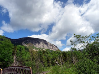
and of Cannon Cliff to the west
The Bike Path leaves the southern end of the parking lot, and soon there is a choice, either continue on the wide, paved Bike Path
or take the Pemi Trail, a genuine trail that parallels the Bike Path.
Since I had a long day ahead of me I chose the marginally easier Bike Path. A short distance beyond the Pemi trail are a pair of large boulders that fell off Cannon Cliff on June 19, 1997. Beside them is a climber's use path to the cliff:
Shortly beyond is a discrete cairn marking another use path:
The rest of the walk down the Bike Path was uneventful until shortly before reaching Lafayette Campground, where an opening gave excellent views both north to Cannon Cliff (note the talus below the cliff)
and south to Little Haystack, with Shining Rock not shining much on a cloudy morning.
To my surprise the southbound parking lot was completely full on a Friday. I crossed under the Parkway to the bigger northbound lot, which was half full.
The Old Bridle path has good footing, as in most areas the rocks are used to make stone stairs and mark the edge of the trail
though there are areas of smooth soil
As soon as the trail leaves Franconia Notch State Park it enters a Forest Protection Area
which is needed to protect such a heavily used trail.
Most of the Old Bridle Path is in the trees, but a short stretch on the crest of the ridge over Walker Ravine has spectacular views. First Mount Lincoln, with its slides and ridges
Then Mount Lafayette with Walker Ravine
Then the ridge crest higher up along which the trail goes, with the steep Agony Ridge
Beyond that the trail is in the woods once again. After climbing up the steep agonies I eventually reached the Forest Protection Area sign for the hut
and soon was having a snack in the hut. After that I slowly climbed to the summit. It was windy, cold and cloudy up there, and I took no photos this time. On the way down I saw the hut getting bigger and bigger as I approached it, here is a view from above
and another from below (near Eagle lake)
I had a very late lunch at the hut, then descended by the Greenleaf Trail. The only really interesting part of that trail is around Eagle Pass. The trail goes through an area of mossy rocks and trees, hard to photograph well. I found a couple of patches of snow in holes under the rocks
and mossy rocks and tree trunks
The trail passes under a steep cliff
On the other side of the pass there is a new (fall of 2009) slide
also here from a different angle
Beyond Eagle Pass the trail goes down, with a few switchbacks, to the area of the Old Man Viewing, where I left the trail and bushwhacked through very open woods to the parking area.
View Lafayette Loop in a larger map
From there I took the Bike path back to the climber's lot, where I had a wonderful view of Eagle Cliff and Eagle Pass in the sun, which had finally come out
The trip was about 7 miles on trail, and 2 on the Bike Path, with 3,600 feet of elevation gain.


Fine way of describing, and nice piece of writing to
ReplyDeletetake information regarding my presentation topic, which i am going to convey in college.
my webpage chiropratique spécifique sherbrooke